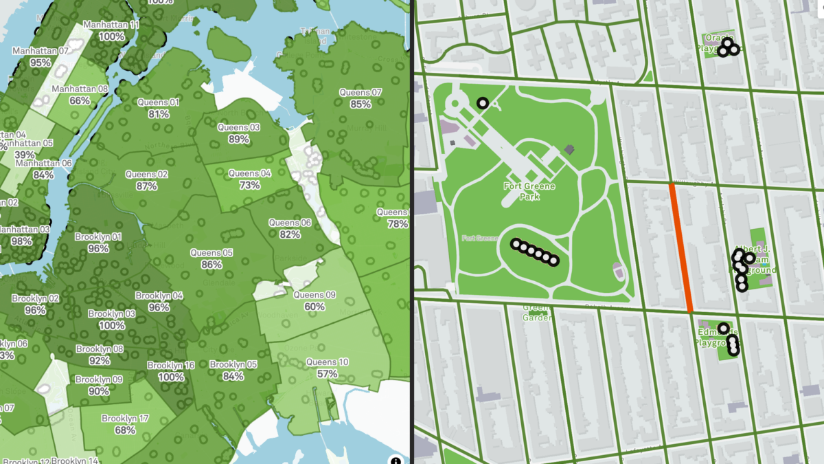
Annually, NYC community-based organizations and the City government work to supply millions of pounds of food directed toward people in need through the Community Food Connection Program. Determining how to distribute limited resources to where they are needed the most, the City leverages data-driven approaches to bring food to those in need using the Supply Gap Analysis. In this workshop, you’ll learn how data insights can shape decision-making, collaboration and support organizers like you to make more informed decisions that facilitate food security for our communities.

Led by the NYC Mayor’s Office of Food Policy, this session will include guests from the Mayor’s Office for Economic Opportunity & Community Food Connection Administrators, whose work supports over 700 food pantries and soup kitchens across the city, leveraging insights from the supply gap analysis in areas of unmet need.

Ideal for food security advocates, academics, students, data analysts and others interested in food-related issues and data, the workshop will provide answers to questions about neighborhood food security metrics, how need for emergency food is defined and measured, and how to leverage the dataset to support neighborhood and/or organizational strategies to close the gap. You will have a chance to interact with the Emergency Food Supply Gap dataset using NYC Open Data tools to pose your own strategic insights to support food security.

You are invited to celebrate and document the vibrant urban ecologies of New York City in an engaging edit-a-thon event. This special day is dedicated to contributing to open data projects and expanding the digital landscape of urban agriculture through collaboration with experienced WikiNYC editors and open data enthusiasts. Whether you are a seasoned Wikipedia editor or new to the process, your knowledge and stories are welcome. Join us to help preserve and amplify the impact of these cherished green spaces!

Hosted By: Farming Concrete, Wikimedia NYC, Prime Produce, Seeds to Soil, Cafe 242 Hell’s Kitchen

Introduction to Wikipedia and Open Data Editing: Learn how to edit Wikipedia and contribute to open data platforms with guidance from experienced editors and open data specialists. Projects will include:
– Open Street Map + Farming Concrete: Mapping community gardens and urban green spaces.
– WikiData and WikiBase: Adding and enhancing data about community gardens, land ownership, and urban environments.
– WikiSpore: Exploring creative documentation and storytelling.
– Open Source Flexibility: If you are interested in editing other open-source projects or platforms not explicitly listed, there will be opportunities to explore and work on them with available support.

Documentation and Story Sharing: Share your firsthand experiences and narratives about community gardens and farms, linking them to credible primary and secondary sources.
Open Data Exploration: Collaborate on projects related to land ownership, urban heat data, and civic ecology.
Contribute Your Visuals: Bring photographs, videos, and other media that capture the essence and beauty of community gardens to enrich the visual narrative.

Together, we’ll document, map, and celebrate community gardens—putting them on the global digital map!

What to Bring:
– Articles of Interest: Publications or written materials relevant to urban agriculture and community gardens.
– Lists and Ideas: A list of community gardens or related projects you’re interested in documenting.
– Photographs and Media: Any media or documentation to help visualize these spaces.
– Reference Sources: Bring any citations or resources to enhance the content.
– Devices: Laptops, tablets, or other devices for hands-on editing.
– Excitement: Bring your passion for learning, sharing, and building community!

Contact and Questions:
If you have any questions or ideas to share, reach out to kellystgreen@gmail.com.

Part II of a presentation on data quality presented by David Tussey, formerly of the NYC Department of Information Technology and Telecommunications and Jun Yan, professor of statistics from the University of Connecticut. Part I focused on how to undertake a data cleansing effort.

This presentation focuses on measuring data quality over time. In this presentation we will examine the challenges of measuring data quality over time; essentially attempting to answer the question “Is my data getting better or worse?”. We discuss some data quality measures, how to capture and visualize these over time, and how to detect deviations in data quality using a process known as statistical process control. We will demonstrate the framework we propose with real-time demonstration of data quality scripts executed against the 311 SR dataset.
At the end, we hope to illustrate both issues and a potential solution for measuring the changes in data quality over time.

This is a virtual presentation illustrating how to undertake a data cleansing effort It is Part I of a two part presentation involving data quality presented by David Tussey, formerly of the NYC Department of Information Technology and Telecommunications and Jun Yan, professor of statistics from the University of Connecticut.

This part will describe the steps of a data cleansing effort, and illustrate those steps via live, real-world examples utilizing data from the NYC 311 Service Request dataset. We will examine the 311 SR dataset for anomalies. It is intended to be an instructional session reflecting lessons learned from our previous data cleansing efforts, augmented by real-time code execution providing examples of each step. By the end, we hope attendees will have a basic understanding of how to go about “cleansing” their own data sets.

Part II, presented on Thursday, 3/27 will deal with evaluating data quality over time in an attempt to answer the question “is the data getting better”?

Open-source is transforming the data engineering space. By combining tools like Parquet, Polars, DuckDB, and Dagster, data product creation can achieve a collective 1000x improvement in cost, performance, and simplicity. Plus — thanks to LLMs, it has never been easier to quickly learn how to build with these tools!

Join Christian Casazza, Data Engineer, where he’ll speak about the Open Data Stack. He’ll show you how to use open-source tools to ingest and store any dataset from the Open Data API, run a SQL transformation pipeline, and visualize the results as a live web app (all for free from your computer!). Then, learn how to work with an LLM like ChatGPT to write ETL code, build SQL queries, and create frontend apps.

Join Data Dissemination Specialist Joli Golden to explore easy to use tools like QuickFacts and Census Narrative Profiles to find free local data to leverage in your grant proposals. See how to access the most current and relevant demographic statistics from the American Community Survey and the 2020 Census in data.census.gov. Take a look at how using different levels of geography in your searches and easy to create thematic maps can help you to build a more compelling case for grants. This training is recommended for all data users.

Have you ever wondered how parks in your neighborhood compare with others? Meet the Vital Parks Explorer! In this session, the Innovation & Performance Management (IPM) team from NYC Parks will share some highlights of how this public-facing tool was built. The Explorer visualizes access to parks amenities and services across the city. From inception and prototype, to public release, three data professionals working in local government will give you a behind-the-scenes look at how data, analysis, visualization, and user experience considerations shaped the final product. This event is for all New Yorkers who care about parks and might be of particular interest to advocates of public spaces, civic data enthusiasts, web app developers, designers, geospatial data scientists and engineers. We look forward to your participation and feedback!

Speaker bios:
Lilian Chin is a Data Analytics Specialist on Parks’ IPM team, where she has worked since September 2023. As part of IPM, she supports a wide-range of data-driven initiatives for Parks’ Maintenance and Operations. This includes visualizing the Work Order backlog, streamlining data pipelines for park assets, developing methodologies for the Park Condition Score, building in-house dashboards, and improving data quality and documentation.

Kate Sales is a Data Analytics Specialist on Parks’ IPM team. In the last year, she has worked on projects that touch many aspects of Parks including collecting and combining volunteer data for the Let’s Green NYC initiative, creating dashboards for Vital Parks for All, and helping others learn how to visualize data. Before Parks, Kate was a GIS analyst at the urban planning consulting firm Urban3 in Asheville, NC, her hometown. She recently completed her Master of Urban Planning at CUNY Hunter College and earned her BA in geography at Macalester College.

Benno Mirabelli is a Data Scientist on Parks’ IPM team. He works on various data analysis, reporting, research, and optimization projects. Some examples of his ongoing work include the routing analysis based on LION data for the recently released Vital Parks Explorer, research on understanding usership patterns and visitor volume at parks, and new management tools that assist with grass maintenance, planning, seasonal worker assignments and more. He holds a PhD in Applied and Computational Mathematics.

This session unveils two dashboards developed by the New York City Council Data team to transform large public datasets into accessible, actionable tools for the City Council. The CouncilCount and Max311 dashboards use data from the U.S. Census and NYC’s 311 Service Requests to offer insights tailored to the unique needs of each Council District.

Join us if you’re curious about creating dashboards for the public good, transforming large datasets into simple visuals, and delivering insights to decision-makers.

During this event, we will walk attendees through the dashboard development process. The CouncilCount dashboard provides demographic, socioeconomic, and other census data, curated specifically to help Council members better understand and serve their communities. Max311, on the other hand, leverages 311 Service Requests to track and analyze trends in community concerns, complaints, and issues reported by district.

The event will be a mix of presentation, live demo, and Q&A. We’ll start with an overview of the Council’s goals and challenges around public data, followed by a walkthrough of each dashboard. After demonstrating specific use cases, we’ll open the floor to questions and discussion on using open data for local government insights.