Join us as we share lessons learned from applying GenAI and Natural Language Processing (NLP) to alternative data sources! We’ll walk through a project where we used Public Pulse Mining to evaluate how the public engages with the General Services Administration’s construction projects and better understand local stakeholder priorities and perceptions.

Then, we’ll dive into an interactive prompt engineering exercise using our master prompt templates for structuring unstructured data. You’ll gain practical takeaways on using AI for public engagement, including how to extract insights from free-text datasets like NYC public meeting YouTube transcripts, 311 feedback, and consumer complaints.

This session is open to all audiences, regardless of technical background. We’ll also share open-source tools and scripts on GitHub so you can apply these methods to your own datasets!

Urban street flooding presents significant challenges for metropolitan areas like New York City, particularly in the face of intense rain events. In this workshop, we will explore the causes and variability of streetflooding using NYC Open Data and machine learning techniques. Building on prior research, we aim to reproduce findings on flood risk factors while incorporating updated data from NYC 311 service requests data and other sources such as the U.S. Census. This approach will enhance our understanding of how socio-economic and infrastructural factors contribute to flooding, offering new insights into the spatial dynamics of flood risk.

The workshop will focus on three key topics: data cleaning to process NYC 311 flood reports and supplementary datasets, exploratory data analysis to identify patterns in flood risk factors, and predictive modeling using Random Forest regression. By analyzing how factors like land features, topography, and population dynamics influence flood risk, participants will gain hands-on experience with urban flood modeling techniques.

Four students from the Spring 2025 Introduction to Data Science course at UConn will present their projects in sequential order, each focusing on one aspect of the core topics. The presentations will be followed by a Q&A session, providing participants with an opportunity to engage with the presenters and explore the findings in greater depth.

  • How confidently can we predict the impacts of zoning change on housing supply?
  • Can we use AI to create novel datasets that may allow us to better understand housing phenomena?
  • What would it take to model a reality in which we build 1 million housing units?

These were some of the questions that led Janita Chalam, an independent researcher with a background in software engineering and machine learning, to begin their research journey into discovering how open data, statistical modeling, and AI can help us tackle the housing affordability crisis.

This presentation will walk through what Janita has learned about the variables at play in NYC’s housing landscape and present a statistical analysis of the Bloomberg-era upzonings as a case study in examining the frictions to building more housing in NYC.

Finally, Janita will propose some ideas for what kind of data and methodologies we might need in order to make bolder claims about what it takes to get us out of the housing crisis. By the end of this talk, we will hopefully have a better understanding of the role that data and empiricism can and should play in our conversations about housing policy.

This talk is for anyone interested in housing affordability and will not require any expertise in the technologies mentioned.

New York City agencies create and publish a huge volume of geospatial data each year. They use Geographic Information Systems (GIS) – computer-based tools to store, visualize, and analyze this geographic data. This panel will review publicly-available tools and datasets, discuss the state of GIS technology in the city, and consider how the City uses geospatial data to serve NYC residents.
Join this conversation with agency GIS leaders about new maps & tools, geospatial data, and initiatives for 2025.

Moderator
Lee Ilan, NYC Mayor’s Office of Environmental Remediation

Panelists
Josh Friedman, NYC Emergency Management
Matt Croswell, NYC Department of City Planning
Carmela Quintos, NYC Department of Finance
Angel Adhikari, NYC Department of Finance


Join our virtual event to discover a cutting-edge tool that pinpoints prime tree planting sites across NYC using NYC Open Data. This model empowers NYC Parks foresters to expand the City’s green canopy more efficiently. The model leverages datasets such as NYC Parks Tree & Site, NYC Planimetrics, DOT Traffic Signs, and the DOH Heat Vulnerability Index to drive site selection. Shawn Ganz, Data & Product Designer with NYC Parks, will break down the model’s purpose, methodology, and data foundations while advocating for greater open data access in urban planning. Wrap up the session with an engaging Q&A and discussion on future applications.

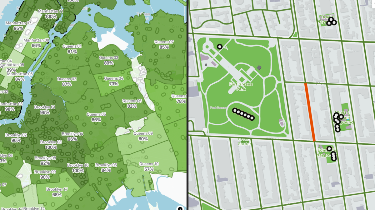
Have you ever wondered how parks in your neighborhood compare with others? Meet the Vital Parks Explorer! In this session, the Innovation & Performance Management (IPM) team from NYC Parks will share some highlights of how this public-facing tool was built. The Explorer visualizes access to parks amenities and services across the city. From inception and prototype, to public release, three data professionals working in local government will give you a behind-the-scenes look at how data, analysis, visualization, and user experience considerations shaped the final product. This event is for all New Yorkers who care about parks and might be of particular interest to advocates of public spaces, civic data enthusiasts, web app developers, designers, geospatial data scientists and engineers. We look forward to your participation and feedback!

Speaker bios:
Lilian Chin is a Data Analytics Specialist on Parks’ IPM team, where she has worked since September 2023. As part of IPM, she supports a wide-range of data-driven initiatives for Parks’ Maintenance and Operations. This includes visualizing the Work Order backlog, streamlining data pipelines for park assets, developing methodologies for the Park Condition Score, building in-house dashboards, and improving data quality and documentation.

Kate Sales is a Data Analytics Specialist on Parks’ IPM team. In the last year, she has worked on projects that touch many aspects of Parks including collecting and combining volunteer data for the Let’s Green NYC initiative, creating dashboards for Vital Parks for All, and helping others learn how to visualize data. Before Parks, Kate was a GIS analyst at the urban planning consulting firm Urban3 in Asheville, NC, her hometown. She recently completed her Master of Urban Planning at CUNY Hunter College and earned her BA in geography at Macalester College.

Benno Mirabelli is a Data Scientist on Parks’ IPM team. He works on various data analysis, reporting, research, and optimization projects. Some examples of his ongoing work include the routing analysis based on LION data for the recently released Vital Parks Explorer, research on understanding usership patterns and visitor volume at parks, and new management tools that assist with grass maintenance, planning, seasonal worker assignments and more. He holds a PhD in Applied and Computational Mathematics.